
Camera alerts while you drive
Drive shows the cameras it covers on your way, with a chime, a voice and the posted limit. It covers speed cameras on the map in Los Angeles, Long Beach, San Francisco and Oakland, red light and traffic cameras, and plate readers such as Flock cameras. It runs in your phone’s browser, or one tap from your Home Screen.
In LA, 26 speed cameras started warnings Oct 26, 2026.
Drive (Beta) chimes or speaks when a camera is ahead. Keep CamsAhead open on your phone.
Speed alerts cover cameras in their warning period or issuing tickets. Red light alerts cover 45 LA County intersections, 33 of them unverified. Email alerts: one summary email a month.
Know when a camera is ahead
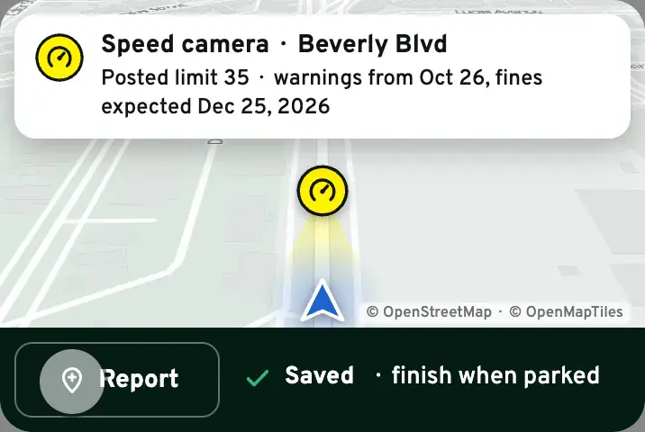
At your alert distance the edge of the screen glows amber, then red as you get close. A big card shows the type, the distance counting down and the posted-limit sign, and a voice says “Speed camera ahead. Posted limit 35.” or a chime sounds.
- Speed, red light, plate readers and traffic cameras, all on to start
- The posted limit, never your speed
- Red light cameras from public lists say “reported”
See it as you pass
As you go by, the camera’s cone reaches toward you, the card says “Camera passed”, and your count goes up by one.
Your drive, drawn behind you
A green line follows you and fades over the last mile. Each camera you pass gets a ring. It stays on your phone, for this drive only.
Share your drive’s scoreboard
At Stop you get a picture of your drive: the cameras you passed by type, the miles and the minutes. It leaves out where you start and end, and it never shows a speed.
A sample drive, drawn the way Drive draws yours.
Report a camera in one tap
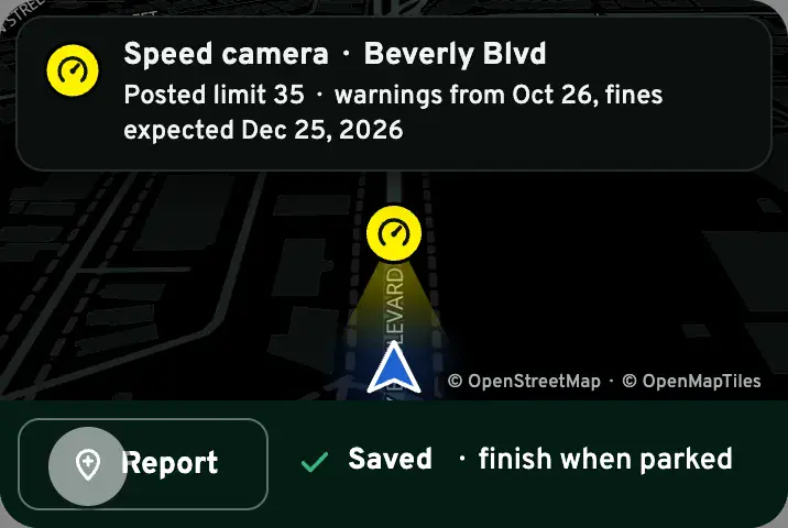
See a camera that isn’t on the map? One tap saves the spot and your direction. When you’re parked, pick the type, check “Is it this one?” and send. It helps keep the map right for everyone.
Set it once, change it on the go
Swipe up for the camera types, the alert distance and the map’s look. Changes save at once, even while you drive.
- Alert distance
- 100 ft to ½ mile
- Map
- Auto (dark from sunset to sunrise), Light or Dark
- Sound
- Voice, chime or off, for each type
Add to Home Screen (iOS & Android)
Keep Drive one tap away. CamsAhead opens full screen from your Home Screen and keeps the screen on while you drive, where your phone allows it. No app store.
iPhone, in Safari
- Tap Share
- Tap Add to Home Screen
- Tap Add
Instagram, Facebook or TikTok opened this page? Their built-in browser can’t add it. Tap “Open in Safari” first.
Android, in Chrome
- Tap Install CamsAhead
- Or the ⋮ menu, then Add to Home screen
- Open it from your Home Screen
On a computer, Drive shows a code to scan: it opens Drive on your phone, with no location in the link.
Free and in beta: before you drive
Alerts can be late, wrong or missing. They work only while CamsAhead is open on screen; lock the screen or switch apps, and they stop. Report a problem
- Set it up parked. Camera types, distance, voice: all before you pull out.
- Put the phone in a mount. Never in your hand or your lap.
- Keep your hands on the wheel. Every control in Drive is one tap. Stop is the big white button.
- Drive the posted limit. The card shows the limit on the sign, never a number above it.
The law, in short
California is hands-free only (Vehicle Code §23123.5). The phone must sit in a mount, and you may touch it only for a single tap or swipe. Drivers under 18 may not use a phone at all while driving (§23124). Laws differ by state.
What starts an alert
A camera of a type you chose is ahead on your path, within your alert distance, and close to your line. If the city published which way the camera faces, it alerts only when you drive that way. If not, it alerts both ways and the card says “Direction not published”. Cameras under construction never alert. One alert per camera per pass.
Email alerts for the places you save
Drive works while the app is open. For the days you are not driving, save a place. You get one summary email a month on new cameras there. All about alerts
Know when cameras near you change.
Free email alerts for cameras on your routes that start issuing tickets. One summary email a month.
- In your monthly summary: the day a camera near you starts issuing tickets
- New cameras mapped or reported near you
- What plate readers keep, and who runs them
- Your street, your distance, the camera types you pick
156,883 cameras listed or mapped so far.
My alerts
Phone alerts need JavaScript in this browser.
Send a notification to this device when a camera is added or changes status near my places.
By tapping Turn on alerts, you agree to the Terms of Use and Privacy Policy.
My places
No saved places yet. Save one from the map or a city page.
Places stay on this device and open offline. With alerts on, we keep each place as an area, or a point rounded to within about half a mile unless you choose your exact spot, never your live location.
Drive questions
Does it use a lot of battery?
About as much as a map app with the screen on. Drive keeps your screen on, so plug in for long drives. You can stop it any time with one tap.
How much data does it use?
Very little. The camera list loads once when you tap Start, about the size of one photo. The map tiles you have seen are kept on the phone.
Where does my location go?
It stays on your phone. Drive reads your position on the device and compares it with the camera list there. Your position and route are never sent to CamsAhead or to analytics. Analytics learns that a drive started and stopped, with your alert settings and how many minutes it ran. If the map is open, the map service loads the streets around you. With alerts on, we keep each place as an area, or a point rounded to within about half a mile unless you choose your exact spot, never your live location.
Is there an app that shows speed cameras?
Yes. Drive (Beta) on this page marks each speed camera on the map in Los Angeles, Long Beach, San Francisco and Oakland with a voice or a chime as you reach it (in Long Beach, as you enter the stretch the city lists), with its posted limit. It runs in your phone’s browser with no account, and you can add it to your Home Screen.
What does it cost?
Nothing. The map and Drive are free, with no account.
Have alert emails started?
Yes. Once you confirm your email, you get one summary email a month for the places you pick, each with an unsubscribe link.
Will this stay free?
Everything here is free today. If we ever add paid features, we'll tell you first, and nothing changes without your OK.
Why can’t I hear the alerts on my iPhone?
Silent mode can mute them. Turn on Play alerts on silent in Drive options, or turn silent mode off. Turn the volume up, and tap the sound chip if Drive shows one. The card on the screen always shows the alert too.
Does it work with the screen locked, or with Waze or CarPlay in front?
No. Alerts work while CamsAhead is open on your screen. Lock the phone or switch apps and they stop; the card says so.
Which cameras alert?
Speed cameras on the map in Los Angeles, Long Beach, San Francisco and Oakland alert in their warning period or once they issue tickets; in Long Beach, once as you enter the stretch the city lists. In Los Angeles that is the 26 listed as “Warning Live”; the 99 still under construction never alert. Tickets are expected from about December 25, 2026. Red light cameras alert at 45 LA County intersections, 33 of them unverified. Plate readers and traffic cameras alert with a chime. Switch any type off in the settings.
Which red light cameras alert?
Drive alerts at the 12 intersections listed in Culver City and at 33 more from public records, marked unverified. It alerts as you drive toward one, the same as for a speed camera. Each pin sits at the center of its intersection. The lists name intersections, not camera spots.
How do I stop it?
Tap the white Stop button. Closing the app or locking the phone stops it too.
A camera is missing, or the alert was wrong.
Drive is free and in beta. Report a problem and say what you saw.
Sources and updates
- LADOT: camera map and corridor table, status Oct 30, 2026
- Culver City: red light lists
- Public records: red light intersections, unverified
- US Census TIGER/Line: roads
- OpenStreetMap contributors: plate readers, data as of Nov 7, 2026; ODbL 1.0
- Caltrans CWWP2: traffic cameras; CC BY
- Statistics Canada: province lines for Drive in Canada. Contains information licensed under the Open Government Licence – Canada. Adapted from Statistics Canada, 2021 Census Cartographic Boundary Files, 2021. This does not constitute an endorsement by Statistics Canada of this product.
Plate reader points are mapped by OpenStreetMap volunteers (data as of November 7, 2026).
How CamsAhead counts cameras · Report a problem · Report a camera