
 CamsAhead.com
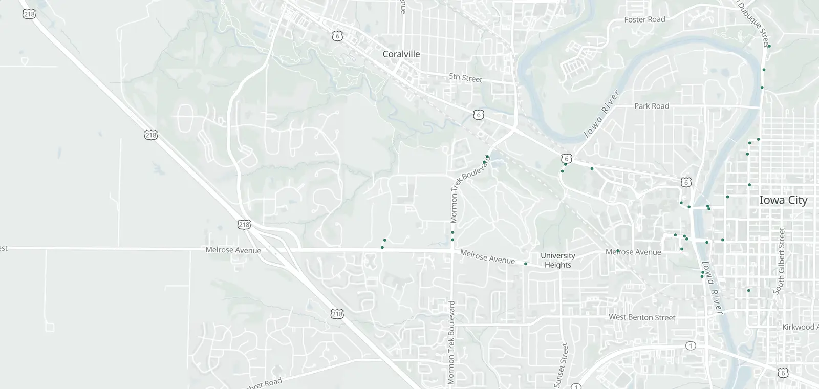
Plate readers © OpenStreetMap contributors (ODbL) · © OpenMapTiles
Iowa City has 33 mapped plate readers. 32 carry the Flock Safety tag. 19 of 32 say who runs them.
They were first mapped between Feb 11, 2025 and Oct 27, 2026. A plate reader keeps a record of each car that passes. Whoever runs it sets how long, within state law.
Flock cameras in Iowa City: locations by ZIP code
ZIP 52242 has the most (27), then 52246 (4) and 52245 (1). Mounted on, where known: 20 on poles, 1 on a building and 1 on a street light.
| Where | Maker tag and operator | Facing | First mapped |
|---|---|---|---|
| Near ZIP 52242 Show on map | Flock Safety Run by: University of Iowa Police Department | Faces west-southwest (as mapped) | Feb 11, 2025 |
| Near ZIP 52242 Show on map | Flock Safety Run by: University of Iowa Police Department | Faces northwest (as mapped) | Feb 11, 2025 |
| Near ZIP 52242 Show on map | Flock Safety Run by: University of Iowa Police Department | Faces west (as mapped) | Feb 11, 2025 |
| Near ZIP 52242 Show on map | Flock Safety Run by: University of Iowa Police Department | Faces east-southeast (as mapped) | Feb 11, 2025 |
| Near ZIP 52242 Show on map | Flock Safety Run by: University of Iowa Police Department | Faces northeast (as mapped) | Feb 11, 2025 |
| Near ZIP 52242 Show on map | Flock Safety Run by: University of Iowa Police Department | Faces west-southwest (as mapped) | Feb 11, 2025 |
| Near ZIP 52242 Show on map | Flock Safety Run by: University of Iowa Police Department | Faces south-southwest (as mapped) | Feb 11, 2025 |
| Near ZIP 52242 Show on map | Flock Safety Run by: University of Iowa Police Department | Faces north-northwest (as mapped) | Feb 11, 2025 |
| Near ZIP 52242 Show on map | Flock Safety Run by: University of Iowa Police Department | Faces north-northwest (as mapped) | Feb 11, 2025 |
| Near ZIP 52242 Show on map | Flock Safety Run by: University of Iowa Police Department | Faces west-southwest (as mapped) | Feb 11, 2025 |
| Near ZIP 52242 Show on map | Flock Safety Run by: University of Iowa Police Department | Faces south-southeast (as mapped) | Feb 11, 2025 |
| Near ZIP 52242 Show on map | Flock Safety Run by: University of Iowa Police Department | Faces north-northwest (as mapped) | Feb 11, 2025 |
| Near ZIP 52242 Show on map | Flock Safety Run by: University of Iowa Police Department | Faces northwest (as mapped) | Feb 15, 2025 |
| Near ZIP 52242 Show on map | Flock Safety Run by: University of Iowa Police Department | Faces south-southeast (as mapped) | Feb 15, 2025 |
| Near ZIP 52242 Show on map | Flock Safety Run by: University of Iowa Police Department | Faces west-southwest (as mapped) | Feb 15, 2025 |
| Near ZIP 52242 Show on map | Flock Safety Run by: Not listed yet | Faces north-northwest (as mapped) | Jun 12, 2026 |
| Near ZIP 52242 Show on map | Flock Safety Run by: Not listed yet | Faces south-southeast (as mapped) | Jul 14, 2026 |
| Near ZIP 52242 Show on map | Flock Safety Run by: Not listed yet | Faces northeast (as mapped) | Jul 17, 2026 |
| Near ZIP 52242 Show on map | Flock Safety Run by: Not listed yet | Faces east-northeast (as mapped) | Jul 17, 2026 |
| Near ZIP 52242 Show on map | Flock Safety Run by: Not listed yet | Faces southwest (as mapped) | Jul 28, 2026 |
| Near ZIP 52242 Show on map | Flock Safety Run by: Not listed yet | Faces northwest (as mapped) | Sep 4, 2026 |
| Near ZIP 52242 Show on map | Flock Safety Run by: Not listed yet | Faces southwest (as mapped) | Sep 8, 2026 |
| Near ZIP 52242 Show on map | Flock Safety Run by: Not listed yet | Faces northeast (as mapped) | Sep 8, 2026 |
| Near ZIP 52242 Show on map | Flock Safety Run by: Not listed yet | Faces north-northwest (as mapped) | Sep 12, 2026 |
| Near ZIP 52242 Show on map | Flock Safety Run by: Not listed yet | Faces east-southeast (as mapped) | Oct 20, 2026 |
| Near ZIP 52242 Show on map | Flock Safety Run by: Not listed yet | Faces west (as mapped) | Oct 23, 2026 |
| Near ZIP 52242 Show on map | Flock Safety Run by: Not listed yet | Faces east-northeast (as mapped) | Oct 27, 2026 |
| Near ZIP 52245 Show on map | Flock Safety Run by: Not listed yet | Faces west (as mapped) | Sep 2, 2026 |
| Near ZIP 52246 Show on map | Flock Safety Run by: University of Iowa Police Department | Faces north-northeast (as mapped) | Feb 11, 2025 |
| Near ZIP 52246 Show on map | Flock Safety Run by: University of Iowa Police Department | Faces south-southwest (as mapped) | Feb 11, 2025 |
| Near ZIP 52246 Show on map | Flock Safety Run by: University of Iowa Police Department | Faces north-northeast (as mapped) | Feb 11, 2025 |
| Near ZIP 52246 Show on map | Flock Safety Run by: University of Iowa Police Department | Faces west-southwest (as mapped) | Feb 11, 2025 |
Near you: Flock camera map near you.
Who runs the Flock cameras in Iowa City
19 of 32 say who runs them.
- University of Iowa Police Department 19
What the Flock cameras in Iowa City keep
- Records
- The plate of each car that passes, with the time and place. Often a photo of the car.
- Run by
- 19 of 32 say who runs them, most often University of Iowa Police Department (19).
- Kept for
- Not published on the map. Each operator sets its own. Flock Safety’s FAQ: “Flock recommends a 7-day default.”
- Who sees it
- Whoever runs it, and those it shares with.
- How to ask
- Read the operator's policy. Or ask the city for its records.
When the Flock cameras in Iowa City were first mapped
Flock-tagged readers here were first mapped from February 11, 2025 to October 27, 2026. 19 of the 32 were first mapped in 2025.
CamsAhead started its daily change log on October 22, 2026. How the map changed.
Flock cameras near Iowa City
Flock cameras in Iowa City, IA: questions
How many Flock cameras are in Iowa City?
32 plate readers tagged Flock Safety are on the map in Iowa City, IA, as of November 7, 2026.
Where are the Flock cameras in Iowa City?
The table lists the most recently mapped ones by ZIP code, and the map shows all of them. ZIP 52242 has the most (27).
Who runs the plate readers in Iowa City?
19 of 32 say who runs them. Whoever runs each one sets how long it keeps the reads and who can search them, within Iowa law.
Which agencies around Iowa City use plate readers?
The EFF's Atlas of Surveillance lists University of Iowa Police Department and University of Iowa Parking and Transportation as agencies that use plate readers.
Which way does each camera face?
All 32 carry a direction tag, and the map draws each one as a cone.
Know when cameras in Iowa City change.
Free email alerts for new plate readers mapped near your places. One summary email a month.
- When a plate reader is first mapped near you
- New cameras mapped or reported near you
- What plate readers keep, and who runs them
- Your street, your distance, the camera types you pick
156,883 cameras listed or mapped so far.
Sources and updates
How this page was made: CamsAhead writes each page type once, then fills it with this place's data from the sources below.
- OpenStreetMap contributors: plate readers in Iowa City, IA, data as of Nov 7, 2026; ODbL 1.0
- Flock Safety FAQ: the default retention quoted in What they keep, read Oct 24, 2026
- EFF Atlas of Surveillance: agencies that use plate readers, data as of Aug 2026; CC BY 4.0
Plate reader points are mapped by OpenStreetMap volunteers (data as of November 7, 2026).
How CamsAhead counts cameras · Report a problem · Report a camera