
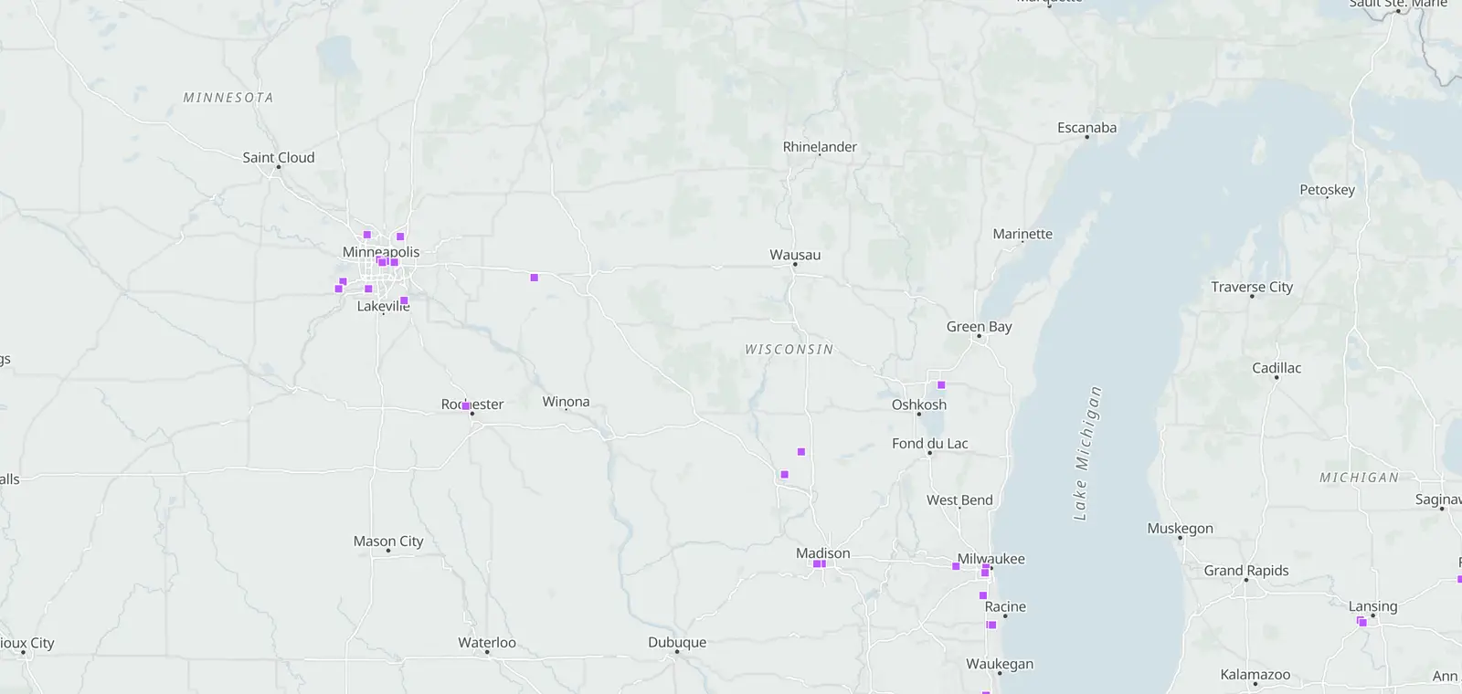
Wisconsin data centers map
Wisconsin has 12 mapped data center buildings, the 30th most of any state. Milwaukee County has the most: 3. 1 large AI campus is being built; the first is expected online in Dec 2028. Businesses pay 13.06¢ per kWh for power, 2% below the US average. Business power use grew 0.8% from 2019 to 2025; the US grew 10.5%.
- 12mapped data center buildings
- 3in Milwaukee County, the most
- 1large AI campus being built
- 13.06¢per kWh for businesses2% below the US average
About mapped buildings
Buildings and sites that OpenStreetMap volunteers have tagged as data centers. It counts mapped objects, not an official register, so some data centers are not on it yet.
About large AI campuses
A large data center campus built for AI computing, on Epoch AI's list of AI data centers. “Being built” means Epoch AI lists no computers running there yet.
About business power prices
This is the average price businesses paid for power in Wisconsin in 2025. A kilowatt-hour (kWh) is the power a 1,000-watt heater uses in one hour.
“Businesses” is the commercial group in the US Energy Information Administration's figures: offices, stores and most data centers. Some large data centers buy power as industry instead.
© OpenStreetMap contributors · © OpenMapTiles
AI campuses: Epoch AI, CC BY 4.0 (Nov 7, 2026), changes noted
© OpenStreetMap contributors · Addresses: Photon
Your location stays on your device.
What the marks mean
Operating: a building mapped as a data center in OpenStreetMap, in use today. As of Nov 6, 2026.
Proposed to under construction, paused, withdrawn or canceled: a planned project and the stage in its latest public record. As of Nov 7, 2026.
About the stages: a project moves from Proposed to Rezoning filed, Approved, Permitted and Under construction. Some stop: Paused, Withdrawn or Canceled.
AI campus: a large AI campus that is not running yet. As of Nov 7, 2026.
Campuses and projects not placed at their street address are listed, not mapped.
Each kind of mark is counted on its own, and the counts are never added together.
Which Wisconsin counties have the most data centers?
Milwaukee County has the most mapped buildings: 3. Dane County and Racine County are next, with 2 each.
Buildings mapped as data centers, per county
- None
- 1
- 2–4
How many in each county?
Which natural risks do these counties face?
About the risk ratings
FEMA's National Risk Index scores each county for each natural hazard from 0 to 100, against every county in the US. The score starts from the expected annual loss: the damage a hazard is likely to cause in an average year. It also weighs how many people could be hurt and how well the area can bounce back.
Ratings run from very low to very high.
“Rate high” means relatively high or very high.
5 of the 8 counties with mapped data centers rate high or very high for at least one natural hazard. Cold wave and tornado are the most common, with 4 each.
What does power cost in Wisconsin, and how fast is demand growing?
Businesses pay 13.06¢ per kWh, 2% below the US average, and their power use grew 0.8% from 2019 to 2025.
What do businesses pay for power?
13.06¢ per kWh in 2025, the 19th highest of 50 states and DC.
Is Wisconsin's power demand rising?
About business power use
This is the power sold to businesses each year, the commercial group in the US Energy Information Administration's figures. Most data centers are in it, so a fast rise often means new data centers, but offices and stores count too.
Wisconsin: 23.55 terawatt-hours (TWh) in 2019, 23.73 TWh in 2025. One TWh is a billion kWh.
Slowly. Business power use grew 0.8% from 2019 to 2025; the US grew 10.5%.
What makes Wisconsin's power?
About the power mix
This is where the power generated in Wisconsin came from in 2025: each source's share of what its power plants made, 66.3 terawatt-hours (TWh) in all. Small rooftop solar panels are not counted.
“Other sources” is the agency's catch-all group.
Natural gas made 36% of the power generated in Wisconsin in 2025; coal made 35%.
Also: wood 1.2%. Under 1% each: other biomass, petroleum and other sources.
How much new power is proposed in Wisconsin?
About proposed power plants
These are new power plants that companies have told the US Energy Information Administration they plan to open from 2026 to 2030. Plans can change or be dropped.
Sizes are net summer capacity: the most power a plant can send to the grid on a hot summer day. Each bar's length is its part of all the proposed power.
Companies have proposed 5,142 MW of new power plants for 2026 to 2030; solar is the largest source, 3,050 MW.
For scale, Wisconsin's power plants could deliver 18,142 MW on a summer day in 2025.
Which grid serves Wisconsin, and what are its water and hazard risks?
MISO runs the grid for all of Wisconsin's power sales. 1 natural hazard rates very high for Wisconsin against other states.
Who runs Wisconsin's power grid?
About the grid
A grid operator, called an ISO or RTO, runs the high-voltage power lines and the power market for a whole region. The share is how much of the state's 2025 power sales were made inside its area.
Where there is none, each utility runs its own part of the grid.
MISO, for all of 2025 power sales.
How much water do Wisconsin's power plants use?
About water taken in and used up
Taken in is the water power plants draw from rivers, lakes, wells or the sea to cool. Used up is the part that does not go back: most of it evaporates.
This is the water power plants use, not the water data centers use.
The 15 power plants in Wisconsin that report their cooling water used up 8.8 billion gallons in 2024, 0.7% of the 1,342 billion they took in.
Which hazards cost Wisconsin most?
About expected annual loss
FEMA's National Risk Index estimates each natural hazard's expected annual loss: the damage it is likely to cause in an average year. It rates each state against the other states, from very low to very high.
Hazards with the same rating are in the order of FEMA's score. Because each hazard is compared with other states, one can rate higher here and still cost fewer dollars than another.
Not rated: avalanche (not applicable), tsunami (insufficient data) and volcanic activity (not applicable).
Cold wave rates highest for Wisconsin against other states: very high for the damage it is likely to cause in an average year.
- Very highCold wave
- Relatively highTornado, strong wind and winter weather
- Relatively moderateHail, lightning, inland flooding, heat wave and ice storm
- Relatively lowLandslide and drought
- Very lowWildfire, coastal flooding, hurricane and earthquake
Which data center projects are planned in Wisconsin?
1 large AI campus is being built in Wisconsin. The first, OpenAI Stargate Wisconsin, is expected online in Dec 2028.
- OpenAI Stargate WisconsinOzaukee County, Wisconsin902 MWexpected online Dec 2028 · full size Dec 2028
Hatched: the MW expected at full size, not built yet. About the dates
What the dates mean
Not yet operating means the site is still being built or planned. Its computers are not running yet. The year shown is when Epoch AI expects them to start.
First online is the month Epoch AI expects the first computers to switch on. Full size is the month it expects the whole campus to be built. Dates can slip.
Epoch AI, a research group, makes these estimates from satellite photos, permits and company news. They can be off by a fair amount.
About MW
A megawatt (MW) measures how much power a site is built to handle at one time. Think of the size of a pipe, not the water that flows through it over a year.
1,000 MW is one gigawatt (GW).
For an AI campus, this is the power its computers are built for, not cooling or offices.
Are there AI data centers in Wisconsin?
Yes. Wisconsin has 2 large AI campuses.
Who runs Wisconsin's data centers?
About this count
Each building counts once, by the operator named in OpenStreetMap. 8 buildings have no operator named.
More about Wisconsin data centers
Questions about Wisconsin data centers
How many data centers are in Wisconsin?
Wisconsin has 12 data center buildings mapped in OpenStreetMap, the 30th most of any state, as of November 6, 2026. Epoch AI tracks 2 large AI campuses here. These counts are kept apart.
What county in Wisconsin has the most data centers?
Milwaukee County has the most: 3 data center buildings. They are mapped in OpenStreetMap. That is as of November 6, 2026. Dane County and Racine County are next, with 2 each.
How many AI data centers are there in Wisconsin?
Epoch AI tracks 2 large AI campuses in Wisconsin, as of November 7, 2026. AI data centers in Wisconsin lists each one. Other data centers here show as mapped buildings or project records, and each is counted on its own.
Sources and updates
How this page was made: CamsAhead writes each page type once, then fills it with this place's data from the sources below.
- OpenStreetMap contributors: data center buildings, as of November 6, 2026; Open Database License (ODbL) 1.0, free copy on request.
- Epoch AI: "AI data centers", CC BY 4.0, retrieved November 7, 2026; changes noted.
- U.S. Energy Information Administration (EIA): Form EIA-861 (released Oct 2026) and Form EIA-861 2025 detailed data (released Oct 2026): business power prices and sales by state, grid operators and utilities by county; retrieved October 31, 2026.
- U.S. Energy Information Administration (EIA): Forms EIA-923/906/920 (released Sep 2026): power generated by source, 2025; retrieved October 31, 2026.
- U.S. Energy Information Administration (EIA): Form EIA-860 (released Sep 2026): power plants proposed for 2026 to 2030; retrieved October 31, 2026.
- U.S. Energy Information Administration (EIA): Form EIA-860 (released Sep 2026): power plant capacity by state, 2025; retrieved October 31, 2026.
- U.S. Energy Information Administration (EIA): thermoelectric cooling water data 2024, Forms EIA-860 and EIA-923 (retrieved Oct 2026): power plant cooling water by state.
- FEMA: National Risk Index v1.20 (December 2025), NRI_Table_Counties and NRI_Table_States: natural hazard ratings by county and expected annual loss by state; retrieved October 31, 2026. This product uses the Federal Emergency Management Agency's OpenFEMA API, but is not endorsed by FEMA. The Federal Government or FEMA cannot vouch for the data or analyses derived from these data after the data have been retrieved from the Agency's website(s).
CamsAhead's project records cover Prince William County, Virginia, not Wisconsin.
How CamsAhead counts cameras · Report a problem · Report a camera